Why ISKRA
The problem
Wildfires start in minutes and run with the wind — every lost minute means more burnt area and more dangerous firefighting. Official satellite products reach the duty officer hours late and are not targeted at specific volunteer teams by area.
The solution
ISKRA fuses 18 independent satellites, detects fires from the raw data itself where official products stay silent, and assembles the finished alert within seconds of the data arriving — with the exact location, terrain, wind, water sources and navigation — straight into the channel of the unit whose area covers the fire.
What makes it different
- Independence. Own infrastructure and open data — not dependent on a paid provider.
- Targeted by area. Each unit receives only the fires in its own area, with navigation from its own base.
- Filters out false alarms. Recognises glint from water and solar farms, industrial stacks and single uncertain detections.
- An operational tool, not a prototype. Running around the clock in the hands of real volunteer firefighters.
Where it is now
The system is live and running around the clock since July 2026. The information reaches 28 registered recipients.
- 19volunteer formations, each with its own area
- 37channels — 17 on Telegram and 20 on Viber, including the national overviews, organisations, a nature park and a works brigade
- 18satellites — polar and geostationary
- 24/7continuous watch over all of Bulgaria
- 40 minmedian from sensing to alert in the channel (measured over 75 fires)
- 1ground station of our own — since 4 September 2026 we receive directly from Hotbird 13G, with no middleman
What arrives in the channel
Here is what an alert for a confirmed fire looks like:
Sample alert
- 🟡 Low risk
- 🟠 Moderate risk
- 🔴 High risk
Risk level in the heading
Beyond the fires themselves
- Terrain and vegetation at the ignition point — gradient, aspect, forest type (from our own relief model and forestry-agency data), key to fire behaviour.
- Topo map of the footprint for coarse detections — the area with trails and elevations for access.
- Water sources nearby — rivers, reservoirs and water bodies around the fire.
- Hazards nearby (power lines, gas pipelines, railways, fuel stations).
- Smoke downwind — which settlements are at risk, plus tomorrow's danger by the European index.
- Lightning — detected by the LI instrument on Meteosat-12; a frequent cause in dry weather.
How units receive the alerts
Every volunteer unit has its own channel (Telegram or Viber) and receives only the fires in its own area — so you are not woken by fires on the other side of the country. The system currently serves twenty volunteer formations across Bulgaria. Recipients number 29 in all — besides the formations there are three national feeds, three organisations, a nature park, a works fire brigade and an association. That makes 39 channels: 18 on Telegram and 21 on Viber.
The channels are intended for the units themselves and access to them is not public — the links are not listed here. The information in the alerts is sensitive and, for now, stays within the operational teams.
Web map of the detections
The channel card tells you what is burning. The map shows the situation — every detection side by side, on the terrain, with everything around it.
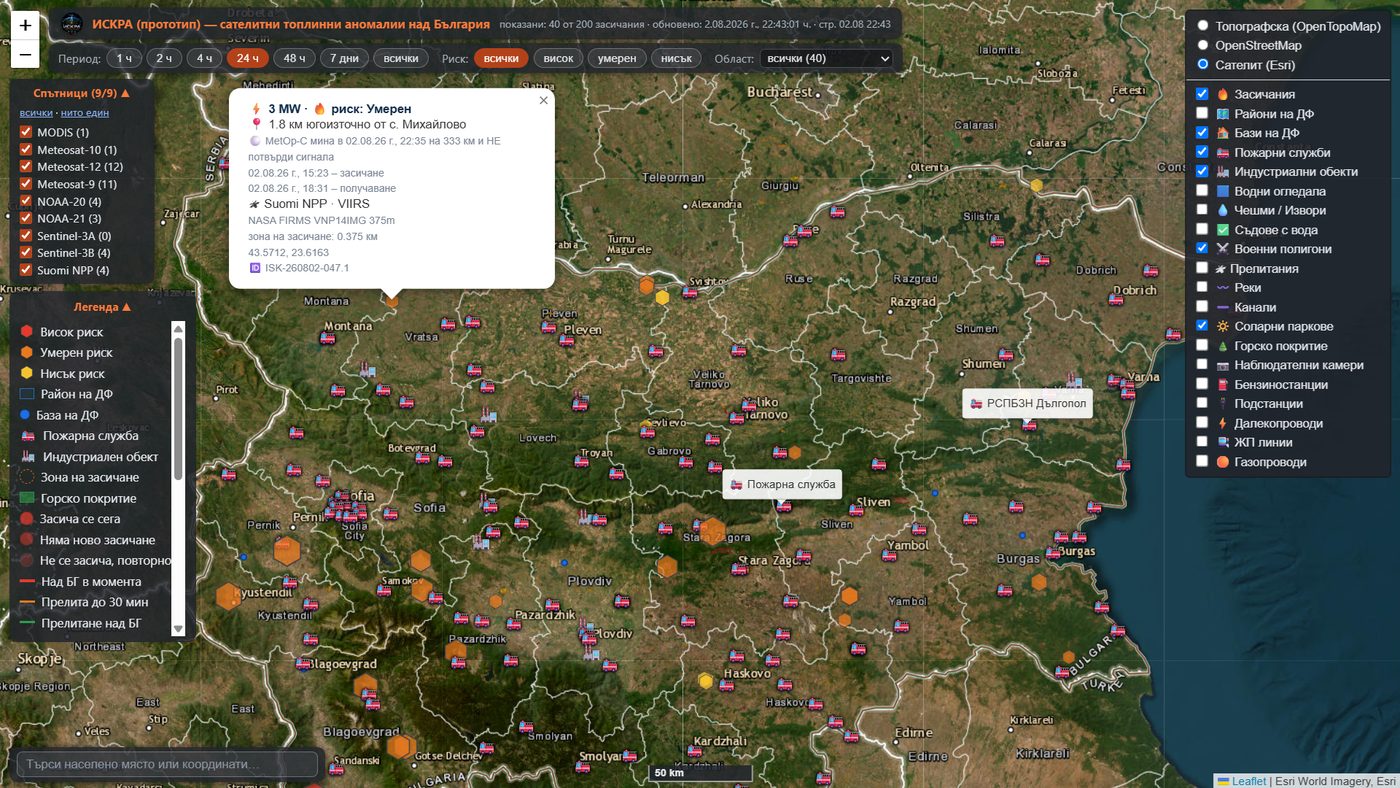
- Every detection with power, risk, time of capture and of delivery, satellite, sensor and fire number.
- State of the fire: fresh signal · no new detection · a fine sensor passed and does not confirm it.
- Satellite passes for the hours ahead — who is coming, when, and how well they will see us.
- Filters by period, risk, satellite and province — the province is outlined on the map.
- Context layers: unit areas and bases, fire stations, water sources, rivers, forest cover, solar parks, military ranges, power lines, gas pipelines and railways.
- Watch cameras with visibility actually computed through the terrain.
The map is a prototype and is still developing. It runs on the same data that produces the channel alerts. (interface in Bulgarian)
ISKRA Balkans — what the system sees across the border
Fires do not stop at the border and neither does smoke. So the same detections we track over Bulgaria are also accumulated over the neighbouring countries — for now only as observation, with no alerts sent to anyone.
A separate map shows those raw detections for North Macedonia, Serbia, Romania, Greece and the European part of Turkey, with the Bulgarian ones alongside for comparison. The difference is visible at once: over the neighbours every point is whatever the satellite reported, while over Bulgaria only the ones that passed our checks and became an alert to a duty crew are shown.
Warning: this is a technology demonstration with unverified data. A detection does not mean a fire. Nobody has been to any of these locations and nothing there has been cross-checked against the known false sources. Do not use it for response.
ISKRA Europe — detections across the continent
The same satellites, seen from further away. The map shows where it burns across 56 countries — from Iceland to the Caucasus, from Norway to Cyprus.
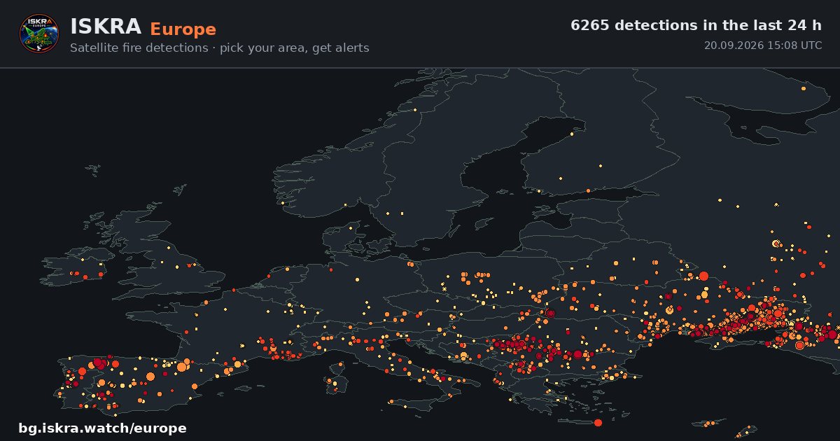
- What it is for: to see whether the season has started, which way it is moving, and whether the neighbours are burning more than we are.
- Fed separately from the Bulgarian map — so that national alerts are not delayed when the continent catches fire.
Open: bg.iskra.watch/europe/
ISKRA 3D — Operations Centre
Fire does not burn evenly. It burns along the slope — and the slope decides which way it goes and how fast. So we built a third view: the terrain in three dimensions, with the forecast laid over it.
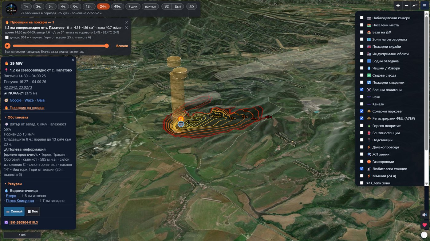
- The forecast sits on the relief — contours at +10 minutes, +2, +4 and +6 hours, with a slider to follow it hour by hour.
- The smoke plume has height — we compute how high it rises, because that decides who will see it and where it will drift.
- Our own relief — 1.6 GB of tiles prepared for the whole of Bulgaria, not taken ready-made from elsewhere.
- Our own Sentinel-2 base layer — another gigabyte or so, so you can see what kind of forest lies under the fire, not a grey schematic.
- More than twenty layers — watchtowers, unit bases, hydrants, water bodies, solar parks, power lines, gas pipelines, military ranges, lightning, blind zones.
- Works offline — installs as an app and keeps the map for your area.
⚠️ The 2D map remains the primary one for the field — it is fast and runs on any phone. The 3D view is for assessment and for the command post; it asks more of the machine and of the connection.
Open: bg.iskra.watch/3dbg/
Where the data comes from
ISKRA does not rely on a single satellite, but on 18. The more independent sources see the same fire, the more certain it is real. The list is ordered by satellite and orbit, then by instrument — one satellite may carry several:
Since 4 September 2026 some of this data arrives directly. Our own ground station receives from Hotbird 13G — without waiting for someone else to process them and publish them online. Since 5 September that path also brings in a whole new satellite — FY-3D, which we would otherwise not have at all.
Geostationary — never blinking, a 5-minute pulse
- Meteosat-12 · 0° (MTG)
- FCI — alert at 2 km, fire power at 1 km. The same satellite also carries LI, which catches the lightning that starts fires, roughly every 2 minutes.
- Meteosat-11 · 9.5° East
- SEVIRI Rapid Scan — a scan every 5 minutes, our own detection
- Meteosat-10 · 0°
- SEVIRI — backup if MTG goes silent
- Meteosat-9 · 45.5° East (IODC)
- SEVIRI — watching from the east, a third independent witness
Polar — passing overhead, looking in detail
- Suomi NPP · NOAA-20 · NOAA-21
- VIIRS — the main workhorse, 375 m per pixel
- Terra · Aqua
- MODIS — coarser picture, but a long record
- Sentinel-3A · Sentinel-3B
- SLSTR — measures the fire's power
- MetOp-B · MetOp-C
- AVHRR — our own night-time detection from the raw data
- FY-3D · Chinese
- MERSI-2 — 1 km, our own detection. The only one we receive on our own dish: about four minutes from acquisition to file. It crosses the Balkans around 5 and 7 in the morning — hours the others rarely cover.
- Landsat 8 · Landsat 9
- OLI/TIRS — 30 m, one pixel is 0.09 ha. NASA's ready-made fire product does not cover our region, so the hotspots are our own detection from the reflected shortwave infrared. It reaches the map only: the file arrives more than three hours after acquisition, and that is the cut-off for an alert.
- GCOM-C (Shikisai) · Japanese
- SGLI — 250 m, our own detection using JAXA's own algorithm. Their ready-made fire product arrives 34 hours after the observation; we read the raw data from their server and are about an hour and a half behind. Checked against their own answer: we find 100% of their hotspots. It works at night only — by day this instrument's signal drowns in reflected sunlight, measured against 20 of our own fires. It passes over Bulgaria around 23:20.
- MetOp-SG A1 · new
- METimage — 500 m and five fire channels. Over the village of Anton a single fire produced three separate pixels where Meteosat gives one three-kilometre blob. The product is still in commissioning, so it sits on its own map layer and does not reach the alerts.
Ground data for assessment
- Copernicus DEM
- the relief — gradient, aspect, elevation
- IAG / Copernicus
- stand type — coniferous, broadleaf, mixed
- OpenTopoMap
- topo map of the footprint for access
- EFFIS / LSA SAF
- fire danger and tomorrow's forecast
- Open-Meteo
- wind and forecast for the fire location
Streams — the full list
The list above is by satellite. But the same satellite reaches us along several different paths, and each path carries a different product with a different delay. So there is a second table — the complete one: 29 streams along 10 separate paths.
- Streams
- 29
along 10 paths - Reach the alerts
- 18
into the channel - Map only
- 6
or used as a gate - Not yet working
- 5
arriving unused
For every stream the table names the satellite, the path it comes by — EUMETSAT Data Store, LSA SAF in Portugal, our own dish, NASA or the Bulgarian met service — the exact product that arrives, what it gives, and whether it reaches the alerts. The delays in it are measured live, not taken from documentation.
Five streams arrive and do not work for us yet. They are in the table on purpose: while they are listed, it is clear what is still waiting.
Where it is heading
- Our own detector on Meteosat’s 15-minute imagery — over the Ljubuša mountain fire in Bosnia our own threshold saw the fire at 12:30, while the ready-made product declared it at 14:30. Two hours of lead time, but only if we receive a frame every 15 minutes instead of every hour.
- Our own VIIRS — the raw data lands on our dish in 7 minutes against an hour along the current path.
- More units across the country, each with its own area.
- More detailed forestry data from IAG — species composition, age, density.
- New sources of information — drones, watchtowers, ground cameras and other sensors to complement the satellite data.
- International exercises and partnerships — the alerts already run in English too.
Important to know
ISKRA is not an emergency service.
In case of fire, call 112. The alert is a support tool for the units, not a substitute for reporting an emergency.
What satellites do NOT see
- Small fires stay invisible — detection starts roughly from a few hundred square metres upward.
- There is a delay — about 5–20 minutes pass between detection and the alert.
- Clouds and thick smoke hide the fire from the satellite.
- False detections are possible — hot roofs and yards, industrial furnaces, glint from solar panels and water. That is why the alert shows the sources, the confidence and the power: verify before you set off.
Why so many sources are needed
A single polar satellite passes over a given point only a few times a day. Between passes a fire can flare up unseen. That is why ISKRA combines polar (detailed, but infrequent) and geostationary (coarser, but continuous) — the day is covered without gaps, and agreement between independent sources filters out false detections.
What ISKRA knows about you
Nothing personal. Alerts are published in channels, not sent to individuals — the system keeps no names, phone numbers or locations.
Support the project
ISKRA is a volunteer, public-benefit and non-commercial project. The costs are low but real — server, maintenance and development. Every contribution keeps the system alive and helps expand it to more areas and teams.
For partners & funders
ISKRA is looking for partners, sponsors and funding (grants, ESA/EU programmes, corporate social responsibility) for sustainable development and expansion. The system is a finished, working operational tool with real end users — volunteer firefighters — which makes it valuable for pilot and deployment projects.
For a presentation, data and a conversation: dobrovolcihisarya@gmail.com
In the media
Press coverage of ISKRA (in Bulgarian):
- Nova TV, “Zdravey, Bulgaria” — “Volunteers from Hisarya built a satellite system that detects fires in real time” (video, 29 Jul 2026)
- BNR, Radio Varna — “Volunteers developed an early-warning system for fires” (30 Jul 2026)
- Frognews — “A system built by volunteers detects fires in real time” (29 Jul 2026)
- Dnevnik — “Volunteers developed an early-warning system” (29 Jul 2026)
- Darik News — “From Hisarya to Space: volunteers launch a real-time system against wildfires” (video, 29 Jul 2026)
- KarlovoPress — “Volunteers from Hisarya created ‘ISKRA’” (29 Jul 2026)
- Bulgaria Novinite — “Volunteers from Hisarya created ‘ISKRA’” (29 Jul 2026)
Team & supporters
- Concept & project
- Zhivko Stefanov — member of DF Hisarya, member of NADRB. Over 100 firefighting call-outs — the system is written by someone who uses it in the field.
- System administrator
- Boris Stefanov (clearlypro.eu)
- Supporters
- The entire community of volunteers in Bulgaria